Preparing Geo Data
Every Geo Map starts with clean location data. When Analytics Plus recognizes the locations in a table—such as countries, cities, postal codes, airport codes, or exact coordinates—it can plot them accurately and help IT teams analyze incidents, assets, sites, services, and operational risks by location.
This page explains the supported geo data types, how to assign a geo data type, how to prepare latitude and longitude values, how to resolve locations that cannot be plotted, and how to use spatial files for custom boundaries and shapes.
- Supported geo data types
- Set the geo data type of a column
- Latitude and longitude
- Zip codes and airport codes
- Unresolved locations
- Spatial data files
- Frequently asked questions
Supported geo data types
| Geo data type | Use it when the column contains | Identified automatically during import |
|---|---|---|
| Continent | Continent names or codes | Yes |
| Country | Country names or alpha-2 and alpha-3 country codes | Yes |
| State/Province | State or province names | Yes |
| County | County or district names | Yes |
| City | City names | Yes |
| Zip Code | Postal codes | No. Postal codes are identified as Positive Number values, so change the data type to Zip Code. |
| Latitude and Longitude | Coordinates in decimal or supported DMS formats | Only when the values use a supported DMS format. Decimal values are identified as decimal numbers. |
| Airport | Three-letter IATA airport codes | Yes |
| Geometry and Custom Geometry | Points or shapes imported from a spatial data file | Yes, when importing a spatial file |
Note: Analytics Plus may not identify a location column when names are misspelled or latitude and longitude values use an unsupported DMS format. Correct the values or assign the appropriate geo data type manually.
Set the geo data type of a column
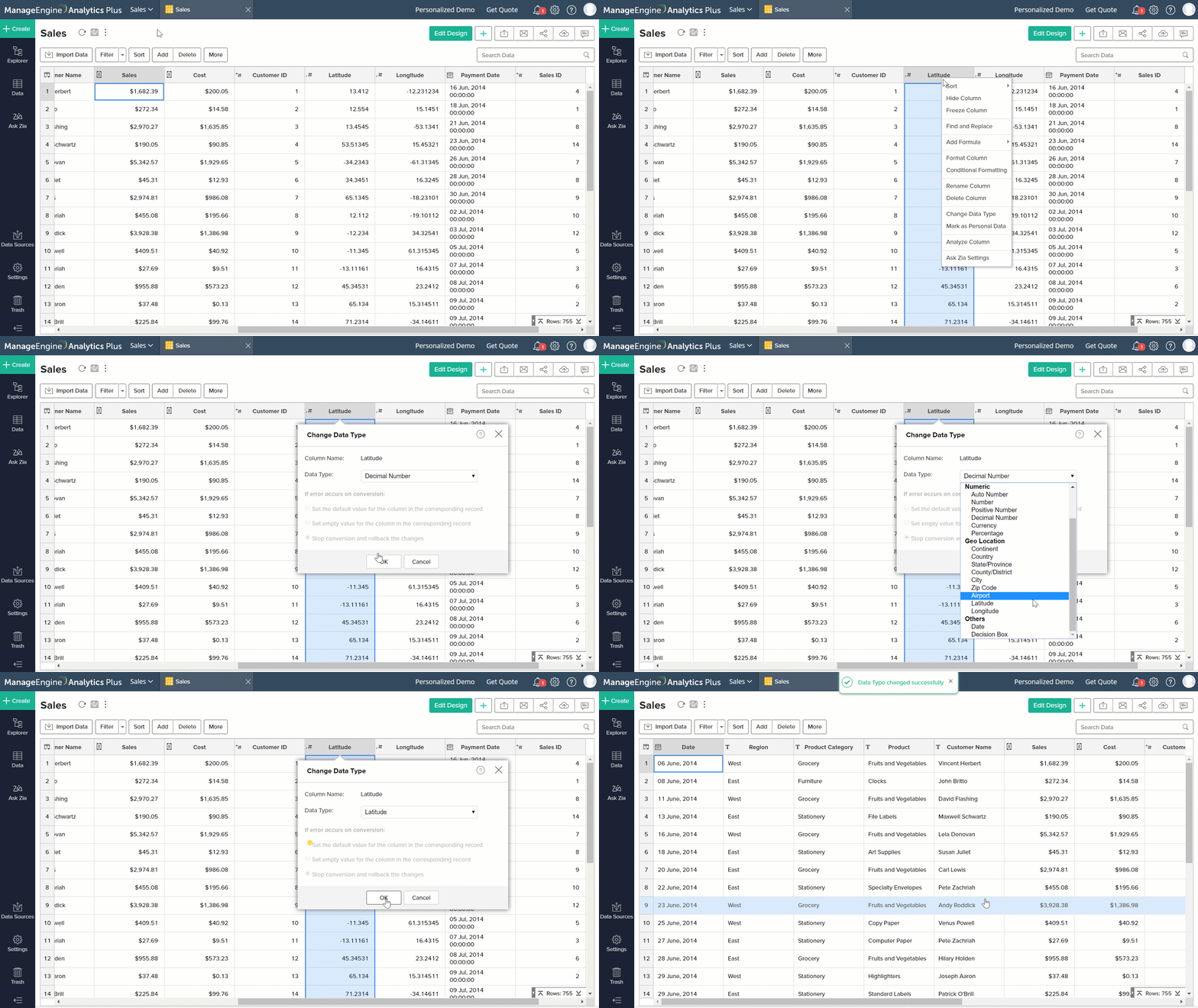
You can set the data type in the Data Preview section during import or change it later from the table.
- Open the table and right-click the column header.
- Select Change Data Type.
- Select the required geo data type from the Data Type drop-down, such as Country, Zip Code, Airport, Latitude, or Longitude.
- Click OK.
Use a column as geo data for one report
If you do not want to change the column's data type in the table, use Treat as Geo in the chart designer. Analytics Plus treats the column as geo data only in that report. For example, you can plot an office location column stored as text without changing its table-level data type.
Latitude and longitude
To plot exact locations, keep latitude and longitude values in separate columns and set their data types to Latitude and Longitude.
To change how a coordinate column is displayed:
- Right-click the Latitude or Longitude column and select Format Column.
- In the Format Column dialog, set the alignment.
- Select a format from the Display Format drop-down.
- Click OK.
Supported display formats include:
- Decimal: (+/-) 12.3456789
- Degrees Minutes Seconds (DMS):
- (+/-) 12° 34' 56"
- 12° 34' 56" (N|S|E|W)
- (+/-) 12d 34m 56s
- 12d 34m 56s (N|S|E|W)
- (+/-) 12.3456°
- 12.3456° (N|S|E|W)
Note: These display formats are available only when the column's data type is Latitude or Longitude.
Latitude and longitude columns can also be binned. In the chart designer, select Geo Location > Hexbin from the function drop-down to group points into hexagonal cells. See Map - Hexbin.
Zip codes and airport codes
- Zip codes: Postal codes are imported as Positive Number values. Change the column's data type to Zip Code before creating the map.
- Airport codes: Analytics Plus identifies three-letter IATA codes as Airport. If a column is not identified automatically, change its data type to Airport.
Unresolved locations
An unresolved location is a place Analytics Plus cannot identify and therefore cannot plot. This can happen when a location name is ambiguous, misspelled, or entered using an informal or colloquial name. During import, these values can appear with the error Invalid GEO LOCATION.
Find unresolved locations
- From a table: Right-click the geo column and select Set Geo Hierarchy.
- From a map: Open the map in edit mode, hover over the chart, and click the Unresolved Location(s) icon in the map toolbar.
Both options open the Edit Unresolved Locations dialog, which lists the locations that could not be plotted.
Resolve unresolved locations
| Method | Use it when | How it works |
|---|---|---|
| Map to a country column | The table contains a country column | Map the location to the country column. If every location belongs to one country and there is no country column, select Provide the Location and enter the country name. |
| Map to a state column | The location remains ambiguous within a country | Map the location to a state column. If every location belongs to one state, use Provide the Location and enter the state name. |
| Correct the spelling | A location name is misspelled | Correct the name in the source data and import it again, or edit it in the Analytics Plus table. |
| Enter latitude and longitude | The exact coordinates are known | Enter the latitude and longitude in the Edit Unresolved Locations dialog. |
| Pick Location | The location is known but its coordinates are not | Click Pick Location, search for the place, select it on the map, and click Apply. Analytics Plus fills in the coordinates. |
Spatial data files
A spatial data file stores the location, size, and shape of geographical features. IT teams can use spatial files to plot custom areas such as service regions, network zones, campus boundaries, or infrastructure coverage areas.
| Item | Supported |
|---|---|
| File formats | Shapefiles as a ZIP file containing all dependent files, TopoJSON, and GeoJSON |
| Geometry types | Point, Polygon, and Multi-Polygon |
| Spatial data size | Up to 15 MB |
To import a spatial file, select Spatial File in the Files/Feeds tab of the import wizard.
- Geometry column: Contains the shape data used to plot locations. Analytics Plus identifies it automatically, and a spatial file cannot be imported without it.
- Custom Geometry column: Contains unique values that Analytics Plus maps to the geometry column. It can be used in place of the geometry column when creating a map.
Import spatial data into an existing table
You can import spatial data only into a table that already contains spatial data, using the Delete existing records and add option.
- Open the spatial table.
- Click Import Data > Import Data into this Table.
- Complete the import wizard as you would for a new spatial file.
Limitations of spatial tables
- A spatial file cannot contain more than one geometry column.
- The geometry column cannot be deleted or excluded when sharing the table.
- A geometry column cannot be used in a lookup relationship, formula, or Auto Analysis. Auto-generated reports do not include it.
- Other file formats cannot be imported into a spatial table.
- Exported or backed-up spatial tables are not saved as spatial files.
Frequently asked questions
1. Why isn't my location column identified as a geo column?
This can happen when names are misspelled, coordinates use an unsupported DMS format, or the column contains zip codes that were imported as Positive Number values. Correct the values and assign the appropriate geo data type. To use the column as geo data in only one report, use Treat as Geo.
2. Should I change the data type or use Treat as Geo?
Change the data type when the column always contains locations. The change applies to the table and its reports. Use Treat as Geo when the column should act as geo data only in one report.
3. Why are some locations missing from the map?
Analytics Plus could not identify them, so they are unresolved. Open the map in edit mode and click the Unresolved Location(s) icon to review and correct them.
4. A city name exists in more than one country. How do I plot the correct one?
Map the location to the country column and, if necessary, the state column. If every location belongs to the same country or state, select Provide the Location and enter its name.
5. Can I use decimal latitude and longitude values?
Yes. Decimal coordinates are imported as decimal numbers, so change the columns' data types to Latitude and Longitude before creating the map.
6. Do latitude and longitude need separate columns?
Yes. Keep latitude and longitude in separate columns and assign the corresponding data type to each column.
7. Which spatial file formats can I import?
Analytics Plus supports Shapefiles packaged as a ZIP file with their dependent files, TopoJSON, and GeoJSON files containing up to 15 MB of spatial data.
8. Can I add more data to a spatial table later?
Yes. You can import only spatial data and must use the Delete existing records and add option. Existing rows are deleted before the imported spatial data is added.